
Hexsor AI-Powered Environmental Intelligence Platform Capabilities
Wildfires are no longer a seasonal, regional event confined to a handful of familiar hotspots. In 2026, record or near-record fire activity has been recorded across the Mediterranean, the UK, and Canada in the same year — three very different landscapes, all facing the same underlying question once the flames are out: what actually happened to the land, and what does it mean for what comes next?
At Hexsor Scientific, we set out to answer that question faster and more objectively than a ground survey alone ever could.
A year of fire, on three continents
Spain is in the middle of one of its worst wildfire seasons in three decades, with hundreds of thousands of hectares burned across the Iberian Peninsula. The UK’s 2025 season was its worst on record, with close to 48,000 hectares burned and the largest single wildfire ever recorded in the country tearing through peatland and moorland in the Scottish Highlands. Canada, meanwhile, has recorded roughly 4.1 million hectares burned so far in 2026, with intense wildfire activity in Northwestern Ontario triggering evacuations of several communities, including First Nations, and wildfire risk reaching areas of Atlantic Canada — including Nova Scotia, where Hexsor’s own Canadian operations are based — that have historically seen far less fire activity.
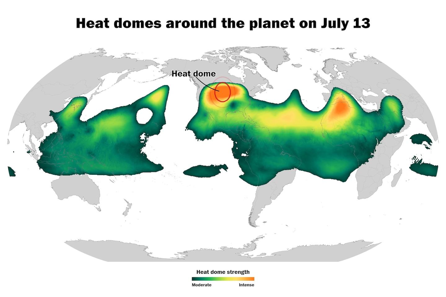
None of this is happening in isolation. August 2026 has brought unusually intense, persistent heat across Europe, parts of Asia, and North America, much of it driven by “heat domes” — large, slow-moving areas of high pressure that trap heat under sinking, compressing air for days or weeks while suppressing the rainfall that would otherwise offer relief. The world’s oceans are running hot too: the Mediterranean recorded its warmest July on record in 2026, and a strengthening El Niño is expected to push global temperatures higher still into the autumn. Together, these conditions are exactly what turns an ordinary dry spell into a record-breaking fire season — and why static, once-a-season monitoring is no longer a sufficient response.
The geospatial challenge
When a wildfire is contained, disaster response teams and land managers face a narrow window in which decisions matter most:
- Information gaps. Ground inspections immediately after containment are hazardous and geographically limited, particularly across large or remote burn areas.
- Resource allocation. Environmental agencies need to identify high-severity zones quickly, in order to deploy soil erosion controls before the next major rainfall.
- Baseline comparison. Distinguishing between naturally dry, dormant vegetation and a genuine burn scar requires clear, objective spatial differentiation — something that’s difficult to judge reliably by eye, especially at scale.
Traditional approaches, periodic field sampling followed by delayed laboratory or desk analysis, simply can’t keep pace with a decision window measured in days.
What we built: a burn severity capability demonstration
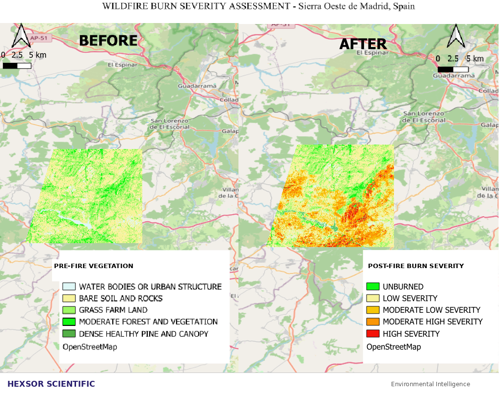
To show what a faster, more objective alternative looks like, our team mapped burn severity across a wildfire-affected region in the Sierra Oeste de Madrid, Spain, comparing landscape conditions before and after a recent fire event.
The output is a clear, color-coded before-and-after picture of the landscape:
- Where forest canopy and vegetation survived largely intact
- Where damage is moderate, and recoverable with the right intervention
- Where vegetation and topsoil loss is most severe, and where erosion risk is highest before the next rains arrive
This kind of analysis can be produced within hours, replacing what would otherwise be a slow, expensive, wide-area field survey with a targeted, remotely sensed layer of intelligence that non-technical stakeholders, policymakers, emergency managers, land trusts , can interpret at a glance.
We built it to demonstrate what’s possible, not to solve a specific client’s problem. But the underlying method is directly applicable wherever a landscape needs to be assessed quickly, objectively, and repeatably after a disturbance event.
Why the map is only step one
Knowing what burned is the first chapter, not the whole story. The environmental risk that matters most to communities, regulators, and land managers often plays out in the weeks and months after a fire is contained:
- Air quality — smoke and particulate impacts on communities downwind, sometimes hundreds of kilometres from the fire itself
- Water quality — ash and contaminant runoff into rivers, reservoirs, and drinking water sources, particularly once rain returns to a denuded landscape
- Soil and ecosystem recovery — tracking vegetation regeneration and erosion risk across multiple seasons, not just in the immediate aftermath
This is where the rest of Hexsor’s AI-powered environmental sensing platform comes in. Alongside rapid geospatial damage assessment, our portable, mobile, and remote monitoring technologies are built to track exactly these post-fire risks, in real time, in the field, giving disaster response teams, environmental agencies, and land managers a single continuous picture that runs from the moment a fire is contained through years of ecosystem recovery.
Beyond wildfire: the same approach, applied broadly
The core idea — pairing rapid remote sensing assessment with continuous field-level sensing to turn environmental change into decision-ready intelligence, isn’t limited to wildfire response. We apply the same underlying approach across a range of sectors facing similar “what changed, and what does it mean” questions:
- Mining & legacy sites — tracking land disturbance, tailings, and water quality across active, inactive, and legacy mining operations
- Maritime & defence — monitoring air and water quality around vessels, ports, and coastal operations
- Spaceport & launch operations — continuous environmental compliance monitoring across marine, atmospheric, and terrestrial zones around launch sites
- Water & industrial discharge — real-time detection of contaminants and emerging pollutants in municipal and industrial water systems
Different sectors, different regulatory frameworks, but the same underlying need: faster, more objective environmental intelligence than a periodic survey can deliver.
Where we go from here
Hexsor AI-Powered Environmental Intelligence Platform was built to demonstrate what’s possible, and we have developed it because we believe more organisations facing post-wildfire assessment, land recovery, or environmental compliance challenges should have access to this kind of real-time capability.
If you work in disaster response, forestry, environmental management, insurance, or public land management, wherever you’re based, and are grappling with post-wildfire or environmental disturbance assessment, we’d welcome the conversation.
Request a demo today and join the future of real-time environmental intelligence.
Analysis conducted by Akhila K, Remote Sensing Analyst, Hexsor Scientific.
